Los Llanos de Aridane
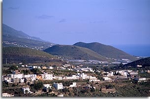
Los Llanos extends over a surface area of 36.2 sq. km and, since the municipalities of El Paso and Tazacorte separated, its borders are largely artificial. Located in the central part of the Valle de Aridane valley to the west of the island, it borders an ancient trackway with El Paso to the east, at an altitude of approximately 600 m. To the north, the Barranco de Las Angustias ravine separates it from Tijarafe. It borders Fuencaliente to the south and Tazacorte to the west, also along arbitrary lines. The majority of the coast is low-lying and it is there that Puerto Naos, one of the island’s most famous beaches, is located.
What was in the aboriginal era an extensive pastureland (the Aridane fief) later became a colonial settlement. This was developed as the owners of the estates of Argual and Tazacorte transported water in channels from the Caldera crater to Llano de Argual, where the sugar industry flourished. As peasant land, this area became intensely cultivated under the landlord system, especially during the XVI and XVII centuries. With the sugar crisis, however, emigration to America intensified from the XVIII century onwards.
The centre of Los Llanos takes shape around the church of Nuestra Señora de Los Remedios and it is in this area that primitive traditional architecture mixes with modern and more advanced structures.
With the development of Los Llanos, administrative independence from Santa Cruz de La Palma was requested on various occasions throughout history but it wasn’t until 1812 that it became a municipality including the areas of El Paso and Tazacorte. These two areas separated from Los Llanos in 1837 and 1925 respectively. In 1868 Los Llanos was declared a villa and later, in 1899, it received city status.
The profitability of banana cultivation and the arrival of settlers from the north-west of the island caused the city’s population to double between 1950 and 1970. Then, as tourism increased, this economic and commercial centre of the valley became one of the most prosperous and developed municipalities in La Palma.
THE BANANA culture in Valle de Aridane
The valley is intensely cultivated and almost entirely covered in a green blanket of banana plant leaves.
The XX century marked the centenary of banana cultivation in the island and the land most recently burned by volcanoes was terraced with fertile soil brought down from higher up the valley. A favourable climate and the know-how of its people enabled decent levels of banana production in the area, and this has remained constant to this day.
The banana plantations form a landscape and a way of life behind which lies a hidden world of dedication and hard work.
The plant variety which has best adapted itself to the land and the prevailing winds is the small dwarf or La Palma variety: its shorter stem opens into a crown with various leaves which protect the bananas from the sun’s rays. The plant’s shallow roots absorb minerals from the soil and the water provided by the farmer through sprinkler systems or drip irrigation. A novel idea brought about a method of irrigation in the neighbourhood of La Vera, whereby owners of crops growing above the water channel could still make use of some of the water from the Caldera – not with mechanical aids but with sheer determination. A dried out pumpkin fitted with a long handle, although today metal is used, served as a receptacle to carry water to their land.
The plant takes a few months to produce its single bunch of fruit. Baby plants shoot up around the parent plant. All of these are removed except the strongest which is allowed to grow to maturity producing more fruit and thus the cycle continues. The flowers are removed from the banana plant to stop the fruit from rotting; this then grows heavier and the plant is supported with forked branches or stakes made of local materials. The bunch is cut when green and when the “fingers” are full – these mature slowly and soon after the parent plant is cut down leaving room for the new generation to grow. Other tasks associated with banana cultivation, which is practised extensively in this area, include fertilisation, spraying and irrigation of the land.
LEGEND OF TANAUSU. Territory of Aceró
The legend of Tanausu is a true story which has been passed on in oral and written tradition. It describes an event that took place around the end of the Spanish conquest of the island.
In 1493, struggling against foreign invasion, the aborigines took refuge in Aceró or “stronghold” (today, Caldera de Taburiente) to resist the attacks of the enemy. The brave Tanausu led the rebels who withstood European raids on two occasions. The Spanish captain, Alonso Fernández de Lugo, decided to arrange a ‘friendly’ meeting to discuss and reach a pact with the native people, but this meeting which took place at Adamacansis Pass was in reality a trick to capture the brave warrior. Tanausu, wary of the meeting, ordered his people to take refuge in the highest and most inaccessible land of the Caldera. Sadly, though, the freezing mountain air took the lives of many of the women, children and elderly and, like a lament coming from the entrails of the earth, the expression Aysuraguán, “the place where they froze”, echoed across the mountain.
Captured thanks to a dirty trick, Tanausu was taken prisoner and many of his people were taken as slaves. Gagged and chained, the leader was shipped to Spain as a trophy. But Tanausu, a lover of freedom and proud of his race, preferred to starve to death on the high seas – thus giving rise to the myth which has stayed with us through the centuries.
FESTIVITIES
At Christmas time it is traditional to visit the spectacular nativity scenes which display the beautiful landscape of the island.
Carnival has a distinct Caribbean flavour to it with its colourful dance troupes, bands of street musicians, performers and clouds of talcum powder.
On July 2nd the city goes all out in its efforts to pay homage to the Patron Saint, Virgin of Remedies. The pilgrimage of St. Isidore and the traditional cattle show are also very popular events.
The Virgin of Anguish is venerated on August 15th.
PLACES OF INTEREST
Los Remedios Church
In front of the church known as Los Remedios, Indian laurels cast a peaceful shadow over Plaza de España, inviting us to stop in this popular spot where local people and visitors converge. This symbolic area is dotted with buildings such as the town hall, the cultural centre, and Nuestra Señora de Los Remedios church itself, constructed on the site of the original chapel built in 1517. The current form of three naves is due to extensions made in the course of the centuries. A harmonious combination of art and ancient Mudéjar tradition is there for all to enjoy. Within the limits of the temple there are sober altarpieces as well as Renaissance statues such as that of Saint Anne, and the Flemish sculpture of the Virgin of Remedies (XVI century), Patron Saint of the municipality.
The most important festivity in the locality takes place every second of July when the island people, devoted to this Marian image, celebrate numerous cultural and religious acts in her honour.
Plaza Chica
Behind the church of Los Remedios, and an indication of a prosperous past, is Plaza Chica, also known as Plaza de Elías Santos Abreu, named after a practitioner of natural medicine born in the area. This architectural complex has a certain colonial air with thin tropical palm trees growing in a small space set around a fountain. The water of the fountain reflects the island’s cobalt blue skies, and the traditional buildings are dispersed around the adjoining side streets. Old stately homes built by wealthy families of past centuries now house small businesses which bring life to the most important finance centre of the area.
Llano de Argual
Travelling in the direction of Tazacorte is Llano de Argual, derived from argal meaning “land in the form of a deep valley”. This enclave was the first colonial settlement in the island and the country estates built on it are the best examples of stately architecture to be found in the valley.
The gigantic monkey-puzzle tree, exotic palms and tropical trees were planted by the resident families in order to stand out over the rest of the people. History relates that a small lagoon fed by the waters of the Caldera once existed here. The small chapel of San Pedro still remains, and the intimacy and peace and quiet in which the masses of past times must have been celebrated may be felt.
As a witness to its economic power in the past, stands the most graceful doorway in the island, now badly positioned, and around which a traditional craft market takes place once a month.
Massieu Van Dalle House
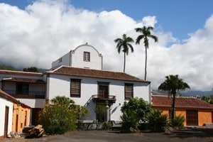 The Argual estate saw some splendid moments in the XVI century, as it was from there that the Monteverde family’s sugar mill operated. According to chroniclers, sugar cane was grown in the estates, where many slaves worked. Camels carried the wood necessary to burn the honey and molasses that were then exported to Flanders.
Water from the Caldera was conducted down channels to operate the sugar mill and to water the cane. The aqueduct from this time still exists.
Massieu house has recently been restored and acquired by the Island Council and local crafts are now sold in this centre which is dedicated to cultural activities.
Las Angustias Church
The river bed of Barranco de Las Angustias ravine marks the border with the municipality of Tijarafe to the north and it is there that the sanctuary of Las Angustias is located. Left slightly ajar, its doors lead to a building comprising a single nave and presbytery and it is visited by devotees of the Virgin of Anguish. With a languid expression, disproportionate forms and stiff robes bordered in gold, the incarnate image of compassion sadly cradles the body of her dead son. This XVI century sculpture is another clear example of the strong relations between the island and Flanders.
Statues of Saint Michael (XVI century) and Saint Ambrose (XVII-XVIII centuries) are also found in it. At the sides of the altar hang small wax votive offerings sent back by Canarian emigrants as a symbol of their devotion as well as relics left on the island by the martyrs of Tazacorte. A commemorative stone plaque tells the tragic story of this group of monks.
Puerto Naos
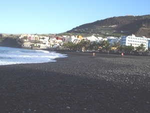
From the centre of the municipality a road leads to the coastal area of Puerto Naos, the tourist resort in the west of the island.
The coastline has been radically changed by volcanic lava rivers which have increased the profile of the coast creating a “low island”. Cliffs alternate with coves, pools and beaches – the most popular being those of El Pocito, Charco Verde, Las Monjas, La Bombilla, Puerto Naos and El Remo.
The human hand, too, has played a part in moulding and transforming the surrounding landscape, and banana plantations are predominant in this volcanic area. The area’s climatic conditions, sheltered from the trade winds, together with long hours of sunlight and low levels of rainfall make it a true paradise with favourable temperatures. But far removed from mass tourism, Puerto Naos is a peaceful place with its kilometre-long beach of black volcanic sand bathed in the warm ocean waters and the bright skies at night.
Protected volcanic landscapes
Dedicated mainly to agriculture, Los Llanos has 23% of its area protected by the Law on Natural Areas (Ley de Espacios Naturales).
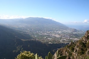
From the excellent scenic lookout at El Time it is possible to admire the most beautiful views over the Valle de Aridane valley. No mountains or forests are visible, only volcanic cones, some belonging to Tazacorte. Covered in giant cacti known as cardones or Canary Island cactus-spurge, and in sweet spurge and broom, the rounded outline of the cones of Argual, Triana, La Laguna and Todoque stand out. Also protected by law is the volcanic tube of Todoque, a natural monument formed by the eruption of the San Juan volcano in 1949. Its twelve mouths, chimneys, terraces, galleries, roof holes, etc. have been sculptured by nature in this 560 m long underground corridor, which is of great scientific and biological interest, due to the invertebrate fauna that live in it.
Copyright. Asociación para el Desarrollo Rural de la Isla de La Palma (ADER-La Palma).